In Haute-Loire, the Suc de Bartou reveals itself through a gradual change of scenery: the banks of the Loire, wooded slopes, then volcanic terrain overlooking the area. For a documented approach on foot, the PR667 offers a loop starting from Chamalières-sur-Loire. The official route sheet gives a distance of 11.6 kilometres, 553 metres of positive elevation gain and an indicative walking time of four hours.
The same peak can also be approached from Vorey-sur-Arzon. ICI presents this second option as a difficult trail, to be run or walked. The two starting points do not refer to the same route: choosing your route before setting your pace is the first useful step in planning the outing.
From the river to the wooded slopes
The PR667 starts and finishes in Chamalières-sur-Loire. Classified as intermediate in difficulty, this waymarked PR loop passes through the communes of Chamalières and Vorey. Its elevation ranges from 511 to 978 metres; the 553 metres of cumulative ascent show that this is not simply a stroll by the water.
The route sheet highlights three distinct settings: the forest on the slopes of Mont Gerbizon, the Costaros rock and the banks of the Loire. The route passes through hamlets and wooded paths, among other places, before reaching the Chomeil area and the discovery trail. The climb to the summit comes next, followed by a descent towards Aunas and the return to the river.
This succession of landscapes is what makes the loop worthwhile. You do not simply reach a viewpoint and immediately retrace your steps: the path offers changing perspectives and leads back to the village by other routes. The official route sheet and its map are the documents to take with you to follow the junctions; this article is no substitute for them.
A different way of looking at volcanic terrain
The word « suc » is part of the region’s volcanic landscape vocabulary. ICI’s feature recalls the role of viscous lava, rising through cracks in the Earth’s crust, in forming these landforms that define the Meygal.
The PR667 route sheet describes a distinctive feature of Bartou: at the end of the eruption, gas pressure is said to have split the volcano in two, leaving two summits. To the east, the Costaros cliff has a face cut into columns and sections that overhang, which climbers appreciate. This rock is part of the landscape; a walking route nearby is not an invitation to improvise a climb on the cliff face.
The discovery trail also offers a chance to take an interest in the local flora and fauna. The document mentions, in particular, the peregrine falcon, the raven and the crag martin. Their presence is another reason to keep your distance from the cliffs: the terrain is also a habitat, and access to it may be adjusted according to the season.
Planning for the exertion and exposed sections
The four hours given for the PR667 are a planning guide. Breaks, experience, weather and ground conditions will all affect the actual duration. On a loop with more than five hundred metres of cumulative ascent, distance alone does not sum up the effort involved: you also need to save energy for the descent and the return.
The route sheet notes an exposed path at the Suc de Bartou. This is worth bearing in mind for people who are uneasy with heights and when choosing an outing for a group. An intermediate-rated trail will not necessarily feel equally manageable to everyone, particularly when the ground is slippery or visibility is poor.
A closure is also possible during the nesting season between stages 6 and 7 of the PR667. In that case, the document indicates a path further south, between Le Chomeil and Aunas. Local instructions and signage in place take precedence over a route recorded earlier. Checking this information before setting off avoids discovering a restriction only when you are close to the section concerned.
Another outing from Vorey
The route described by ICI starts in Vorey: it crosses the Loire, climbs steeply alongside the gorges, reaches a plateau and then the hamlet of Suc Eyraud. A further climb through the forest leads towards the summit. The return route described follows a narrow path between beech and pine trees, then quieter tracks towards the gorges and the starting point.
The feature gives a time of two to three hours running and half a day on foot, and says to bring provisions. These times apply to this route from Vorey. The 11.6 kilometres and 553 metres of elevation gain, meanwhile, belong to the official loop from Chamalières: applying them to the Vorey trail would mean planning an outing using figures for a different route.
To reach the PR667 starting point, the route sheet locates Chamalières-sur-Loire on the D103, thirty kilometres north-east of Le Puy-en-Velay, and recommends parking in the village centre beside the road. Once you have chosen your route, consulting the map and local information lets you focus on what makes Bartou worthwhile: moving from river to forest, then reading part of the landscape’s volcanic history in the shapes of the summit.
References
- ICI, trail route to the Suc de Bartou from Vorey
- Haute-Loire, official route sheet for the PR667 « De la Loire au suc de Bartou »
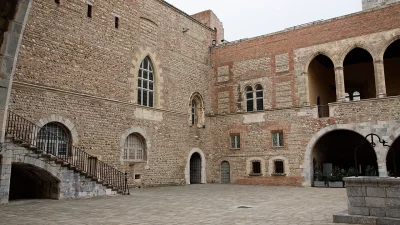
The Suc de Bartou seen from Chamalières-sur-Loire, in Haute-Loire.
Credit: Torsade de Pointes — Wikimedia Commons — Public domain.